Create/ Modify Function
![]()
Function
Define a spatial function which is used to apply location-varying load and boundary conditions.
A function can be defined by filling the table on the left or by writing a numerical equation on the right. The value between two inputs will be determined by linear interpolation.
Call
Model > Function
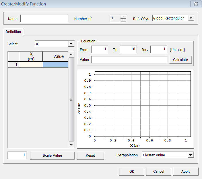
<Create/Modify Function>
Name
Enter
the name of function.
Number of Variables
Specify
the number of variable (1 or 2) in the function.
Ref. Csys
Selected
the reference coordinate system of the function.
Select Variable
Select
the variable in the function.
Equation
Write
a numerical equation to define the function.
From, To, Inc
Specify
the domain of the selected variable.
Value
Enter
a value or an equation. The name of variable must be kept as it is specified.
(Rect. Csys: X, Y, Z, Cylid. Csys: R, T, Z)
<Example>
(1) In the rectangular coordinate system, define a function of 2*X^2 from X=0 to X=100 with an increment of 5;
From: 0, To: 100, Inc: 5, Value: 2*X^X
(2) In the cylindrical coordinate system, define a function of sin(T) from T=0 to T=360 with an increment of 10;
From: 0, To: 360, Inc: 10, Value: sin(T)
Calculate
Fill
out the table on the left based on the equation defined in Value.
Scale Value
Enter a scale factor and press the scale button. The scale factor will be multiplied by the original function value.
Note: The original function values will
be overwritten.
Reset
Reset
all function definitions including variable and value.
Extrapolation
Select
a method to calculate values which exceed defined domain.
Set to Zero
Set
them to 0.
Closest Value
Set
them equal to the closest value.
Linear Extrapolation
Calculate them using linear extrapolation.
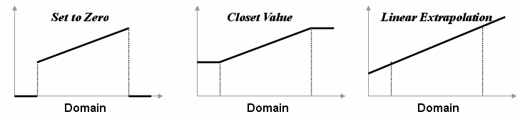
<Extrapolation>